An attempt to remap Europe and claim back the lost territories of the North Sea
- [intlink id="41" type="post"]More about this project[/intlink]


Before I embark on mapping this territory, I think I should initially give Doggerland a (provisional) identity. The flag is based on a section of the dazzle on the SS War Drake, built in Glasgow in 1918. A dazzle-painted model of the ship is held by the Riverside Museum. In a letter to The Times […]
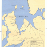
In the Prehistoric Society’s 1998 annual journal, the archaeologist Bryony Coles contributed a survey of the land that had once existed under the southern North Sea.* She named this place “Doggerland” (after the Dogger sandbank) and pointed to evidence of a distinct landscape and a unique people who had left behind tools different from those […]
